1. Aerial Surveying vs. Aerial Photography: The Centimeter-Level Difference
Aerial photography asks one question: does it look good? Aerial surveying asks three: is it geometrically accurate, is it spatially complete, and can every pixel be traced back to a verified ground coordinate? The gap between the two disciplines is measured in centimeters — and in industries that pay by the cubic meter of earth moved, those centimeters translate directly into contract value.
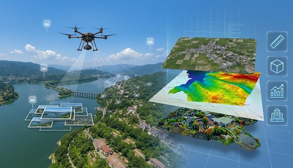
Drone surveying converts physical terrain into measurable, analyzable spatial data. Unlike cinematography, which prioritizes composition and lighting, surveying demands positional accuracy, geometric fidelity, and complete coverage with no data gaps. The deliverable is not a video file. It is a survey-grade orthomosaic, a classified point cloud, or a digital terrain model that a civil engineer can stake a foundation on.
2. Field Data Collection: The Six Steps That Determine Everything
No amount of post-processing can recover data that was never captured. Field operations set the ceiling on deliverable quality. The standardized workflow has six sequential steps, each with a specific failure mode:
2.1 Site Reconnaissance
Walk or drive the survey area perimeter. Identify takeoff and landing zones with 10-meter clearance in all directions, free of overhead obstacles. Mark temporary no-fly zones — active construction crane swing radii, adjacent airport approach paths, sensitive wildlife areas. Assess terrain relief: elevation variation exceeding 20% of planned flight altitude requires terrain-following flight mode rather than constant-altitude transects. On a DJI Matrice 350 RTK, terrain follow is configured in DJI Pilot 2 by importing a DSM of the survey area and setting the aircraft to maintain a fixed height above the terrain surface rather than a fixed altitude above takeoff point.
2.2 Ground Control Point Layout
Ground control points anchor the aerial data to real-world coordinates. Without GCPs, even RTK-tagged imagery drifts by 2-5 centimeters in absolute position. Place 5-8 GCPs distributed across the survey area — one near each corner, one in the center, and additional points where terrain changes significantly. Each GCP is a 60cm x 60cm black-and-white checkerboard target, secured flat to the ground with steel stakes if on soil, or adhesive on hard surfaces. The target must remain stationary and visible from the planned flight altitude.
2.3 RTK Coordinate Measurement
Survey each GCP using an RTK GPS rover communicating with a local base station or NTRIP correction service. Record the GCP center coordinate with a minimum observation time of 10 epochs (approximately 10 seconds) to average out satellite geometry fluctuations. Verify that the horizontal RMS is below 2 centimeters and vertical RMS below 3 centimeters before moving to the next point. The DJI D-RTK 2 base station provides local RTK corrections with a 5-kilometer effective radius, sufficient for surveys up to 75 square kilometers from a single base position.
2.4 Flight Route Planning
In DJI Pilot 2 or DJI Terra, define the survey polygon boundary. The software auto-generates parallel flight transects based on four parameters: flight altitude (determines ground sampling distance), forward overlap (70-80%), side overlap (60-70%), and flight speed (5-10 m/s for photogrammetry). A 100-meter flight altitude with a DJI Zenmuse P1 (45MP full-frame, mechanical shutter) produces approximately 1 cm/pixel GSD. Reducing altitude to 50 meters halves the GSD to 0.5 cm/pixel but quarters the coverage per flight — a trade-off between resolution and efficiency that must be decided per project specification.
2.5 Automated Flight Execution
The aircraft launches, flies the programmed transects, and returns autonomously. The operator's role during flight is monitoring: battery voltage sag under load, RTK fix status (must remain Fixed, not Float), image capture confirmation at each trigger point, and airspace observation for conflicting traffic. On the DJI Matrice 350 RTK, TB65 intelligent batteries provide approximately 47 minutes of hover endurance at sea level. In survey flight at 8 m/s with the P1 payload, effective mission time is 35-38 minutes before the 25% battery return threshold triggers.
2.6 Field Quality Check
Before packing up, verify on the controller: all planned flight lines executed, image count matches expected triggers, no gaps in coverage visible in the thumbnail strip, exposure consistent across the entire flight, no motion blur on the last images of each transect (where crosswind effect is strongest during the turn). If any check fails, the aircraft can be relaunched to recapture the affected area before moving GCPs — impossible once you leave the site.
3. Office Data Processing: Turning Photos Into Survey Products
3.1 Data Import and Image Quality Control
Import raw images, POS data (camera position and orientation per shot from the aircraft's GNSS and IMU), and camera calibration parameters into the processing software. DJI Terra reads this data directly from the P1 or L2 sensor's storage media. Mark GCP positions in the images: click the center of each checkerboard target in at least 5-8 images where it appears. The software uses these marked positions to tie the photogrammetric reconstruction to absolute ground coordinates.
3.2 Aerial Triangulation
The software identifies common feature points across overlapping images — typically 10,000-50,000 tie points per image pair — and solves for the 3D position of each point and the refined camera position for each image. This bundle adjustment process is computationally intensive: a 500-image dataset takes 30-90 minutes on a workstation with 32GB RAM and a dedicated GPU. The output is a sparse point cloud representing the survey area's geometry, plus refined exterior orientation parameters for every image.
3.3 2D vs. 3D Reconstruction
2D reconstruction answers "where, how large, what boundary." Products include a Digital Orthomosaic Map (DOM) — every pixel geometrically corrected to remove terrain distortion — and a Digital Surface Model (DSM) or Digital Elevation Model (DEM). Applications: area measurement, boundary extraction, construction progress comparison, base mapping. Limitation: building facades and vertical structures are not recoverable from nadir-only imagery.
3D reconstruction digitizes the physical world. Products include a dense 3D point cloud, a textured mesh model, a DSM, and derived outputs such as contour lines, volumetric calculations (cut/fill for earthworks, stockpile volume), slope analysis, and building morphology extraction. The DJI Zenmuse L2 LiDAR payload is particularly suited for 3D reconstruction in vegetated or complex terrain — its 240,000 points per second and 5 returns per pulse produce bare-earth digital terrain models under forest canopy that photogrammetry cannot achieve.
3.4 Accuracy Verification and Export
Check residuals at GCPs and independent check points. The RMSE at each GCP should be within the project specification — typically 5 centimeters for survey-grade work. If any checkpoint exceeds tolerance, inspect the marked GCP positions for misidentification, verify the RTK coordinates were recorded correctly, and re-run the bundle adjustment if necessary. Export final products in industry-standard formats: GeoTIFF for orthomosaics and DEMs, LAS/LAZ for classified point clouds, DXF/DWG for contour lines, and OBJ/FBX for textured 3D models.
4. Equipment Selection: Five Decision Rules
Small-area surveys (under 2 km²): RTK multirotor + mapping camera. The DJI Matrice 350 RTK with Zenmuse P1 covers this use case. Multi-rotor platforms offer vertical takeoff and landing from confined spaces — building sites, urban lots, quarries — without requiring a runway or catapult launch.
Large-area surveys (over 2 km²): VTOL fixed-wing + mapping camera. Fixed-wing airframes deliver 90-120 minutes of flight endurance at 15-18 m/s cruise speed, covering 5-8 km² per flight. The trade-off is maneuverability — fixed-wing aircraft cannot hover for detailed inspection of a single structure.
High-precision 3D modeling: Multi-rotor or fixed-wing + oblique camera (five-lens). Five-lens systems capture nadir and four oblique angles simultaneously, providing the multi-view imagery needed to reconstruct building facades and vertical surfaces. The DJI Zenmuse P1's smart oblique capture mode rotates the gimbal to capture forward, backward, left, and right oblique views in sequence — achieving similar coverage with a single lens at the cost of additional flight lines.
Vegetated or complex terrain: LiDAR is mandatory. Photogrammetry sees the canopy surface. LiDAR sees through it. The DJI Zenmuse L2 on a Matrice 350 RTK is the standard configuration for forestry, power line corridor mapping through wooded areas, and mining surveys where stockpile volumes under vegetation require bare-earth elevation data.
Survey-grade formal deliverables: Full configuration required — RTK or PPK positioning, minimum 5 ground control points, independent check points, and a formal accuracy report. This is not optional for projects requiring regulatory approval, legal boundary determination, or engineering design input. The DJI D-RTK 2 base station, combined with survey-grade GCP targets and third-party verification software, provides the traceable accuracy chain that satisfies ISO 19158 geographic information quality standards.
5. Summary: The Surveying Formula
Drone surveying follows a clear chain: Right Equipment → Scientific Collection → Precise Processing → Quality-Assured Delivery. The barrier to entry is not flying the aircraft. It is understanding how to collect data that meets a specification, process it to extract actionable measurements, and deliver a product that a professional surveyor can certify. The drone is a tripod with wings — the tripod holds the sensor, the sensor captures the data, and the surveyor's expertise determines whether the output is a pretty picture or a legally defensible measurement.
Configuring a drone surveying system for your specific project requirements? We supply integrated solutions — DJI Matrice 350 RTK platforms with Zenmuse L2 LiDAR or P1 photogrammetry payloads, D-RTK 2 base stations, ground control point kits, and DJI Terra processing software. Contact our technical team with your typical project area, terrain type, and accuracy requirements for a customized equipment configuration and workflow recommendation.